Road to disaster
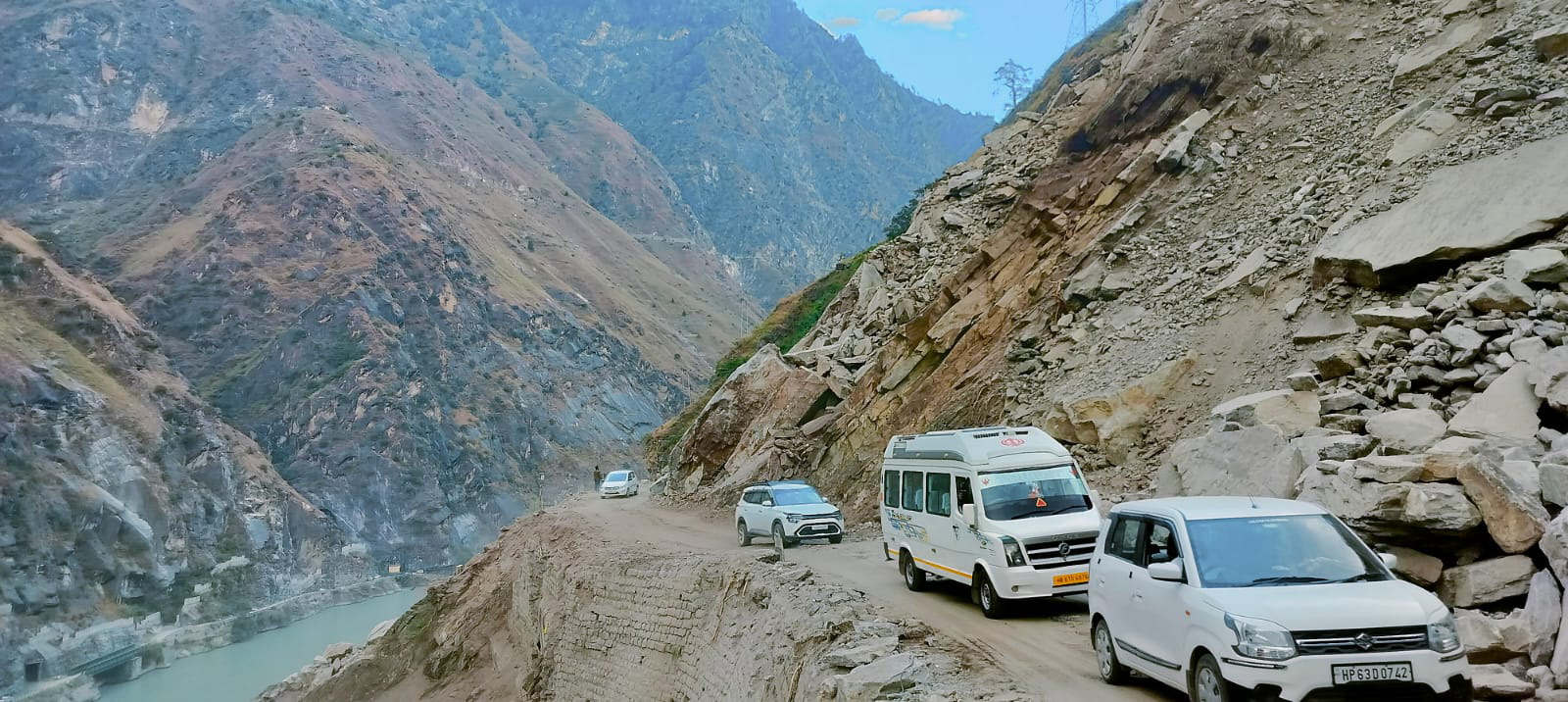
ANOTHER monsoon, another season of carnage in the Himalaya. Cloudbursts, flash floods and landslides tear through road after road, from expansive highways to narrow village routes. Asphalt that not long ago was touted as a beacon of progress now lies torn asunder.
In Himachal Pradesh, 822 roads, including three national highways, have been blocked due to landslides, flash floods and cloudbursts from June onwards, with economic losses reported to be around Rs 3,056 crore, attributing most damage to roads, bridges, power and water systems.
Uttarakhand has suffered losses exceeding Rs 1,000 crore, with over 2,600 roads damaged this monsoon, costing the Public Works Department (PWD) nearly Rs 555 crore. In Jammu and Kashmir, cloudbursts in Kishtwar, landslides near Vaishno Devi and flooding in Jammu city have damaged hundreds of roads while claiming several lives.
Of all the devastation, it is road damage that is perhaps felt most acutely. Roads are the arteries of the mountains: when they fail, the ripple effects spread far and wide. Unlike a damaged power line or a flooded field, which can often be repaired or recovered locally, a broken road severs the link of communities to the outside world. It is not just vehicles that stop; trade stalls, supplies run dry, schools and hospitals become unreachable, and entire valleys slip into isolation.
Every year, promises are made to build back better. Every year, the rains prove how fragile the fixes remain.
Crisis of own making
It is convenient to blame the damage on “natural” disasters. Yet, every landslide and washed-out road underscores the fact that such disasters are never natural, they are constructed by human design.
Hill cutting at near-vertical angles, blasting for faster progress, and dumping construction waste blatantly into rivers create vulnerabilities that the rain merely exposes. If the weather is the trigger, the fault is often engineered.
Today, speed and scale have colonised the language of road infrastructure. Performance is counted in kilometres opened and travel times shortened. Too often, these metrics override questions about slope protection, sustainable drainage, or culverts large enough to absorb a cloudburst’s impact.
Ignoring traditional wisdom
For centuries, Himalayan communities have built paths that bend with the mountain rather than bulldozing through them. Traditional alignments followed ridge lines where drainage was natural and incorporated resilient construction materials. Homes and markets were built on stable ground, away from flood-prone valleys.
Today, such practices are dismissed as “backward”, yet village paths endure for generations while modern highways collapse within a few seasons.
Himachal’s kuhl irrigation system shows how tradition works with, and not against, the mountain. For centuries, these community-managed channels have diverted glacial melt and stream water through gently-sloped earthen conduits, feeding terraced fields without destabilising the hillside. In contrast, modern roadside drains are often cut steep and narrow, sending storm water surging in torrents that rip into slopes and roadbeds. Where the kuhl slowed water down, today’s designs speed it up, with devastating consequences.
Weight of tourism
Underlying the frenzy of expansion is the region’s growing reliance on tourism. Local economies, tethered to visitor numbers, demand wider roads and faster access, often in ecologically-sensitive zones. From the western Himalaya to the Northeast, new road alignments are blatantly carved through known hazard zones, leading to disasters that destroy rather than promote tourism.
Tourism can bounce back once the rains recede, but other sectors cannot. Himachal’s horticulture industry, valued at Rs 4,500 crore annually and employing nearly 2.5 lakh people, risks losing entire harvests when roads close. Apples stranded on blocked highways are income gone forever, wages unpaid and loans defaulted.
“Tourism is our mainstay here in Tirthan. Guests come because the valley feels unspoiled, unlike Sainj next door where hydropower projects scarred the landscape and pushed visitors away,” says Karan Bharti, a homestay owner in Kullu. “For years, we believed we had been spared that fate, but now wider roads are cutting into our slopes, and already we are seeing frequent landslides and closures. More tourists may come for a while, but if the carrying capacity of the valley is ignored, it is not just the roads but the very foundation of our livelihood that could collapse,” he adds.
Paths that endure
Roads are promoted as lifelines — for growth, for emergencies — but the way they are built often multiplies the very risks they are meant to mitigate. Building better roads requires resilience applied at the design stage, not as a post-monsoon patch.
Hazard and vulnerability mapping, through geological surveys and local knowledge, should guide corridor selection. Where high-risk stretches are unavoidable, design must adapt — rock-fall galleries, debris channels and high-capacity culverts are not luxuries but necessities. We must also embrace the “living mountain”. Bio-engineering — vegetative mats, slope-stabilising shrubs, soil nailing with geotextiles — can arrest erosion and soak runoff in ways concrete cannot. Such measures need time to mature, which is why they must be installed before slopes are denuded.
Local knowledge is equally vital. Old mule tracks and traditional alignments reveal ridge lines that endure and terraces that reduce runoff. Integrating such wisdom with modern engineering yields roads that last.
“Earlier, when new roads were planned in the hills, we often spent years studying slopes before laying the foundation, testing its stability, drainage and local geology. Today, the push for speed and wider roads often compromises on these safeguards,” says JC Belwal, a retired Superintending Engineer, PWD, Uttarakhand.
Easing the pressure
The deeper challenge is reducing pressure for road expansion by diversifying mountain economies. Value addition in agriculture can fetch higher prices than the same amount of raw produce, reducing the need for expanding roads to transport more produce.
Modernising production in cottage industries like handicrafts can provide scale for small businesses to thrive. Investment in digital connectivity through high-speed Internet can enable remote work, creating new livelihood opportunities and reducing the imperative for constant road expansion.
Global lessons
In the Swiss Alps, after devastating rockslides in 1991, engineers rerouted vulnerable corridors, built bypass tunnels and reinforced slopes. Today, Switzerland relies on hazard maps that dictate where roads can and cannot be built, blending engineering with detailed land-use planning. Even in hazard-prone regions, closures are now fewer and economic losses contained.
Japan’s mountain highways are designed to coexist with hazards. Builders combine slope stabilisation, rockfall nets and drainage with comprehensive monitoring and early warning systems. Geohazard risk management is embedded from planning through maintenance, keeping roads open despite quakes and cloudbursts.
In the Peruvian Andes, rural mountain roads upgraded with risk-based design and bio-engineering have reduced rain closures dramatically.
What lies ahead
The Himalaya will always be a challenging landscape to build in. That is precisely why every cut into its slopes must be made with caution and foresight.
The choice before us is clear: continue the cycle of speed and spectacle or commit to roads that respect the mountain geology. If other countries can find ways to adapt to fragile mountain terrain, so too can India’s Himalayan states.
— The writer is an outdoor enthusiast and climate expert
DANGEROUS STRETCHES
 The Hindustan-Tibet road on National Highway-5 near Nathpa at Kinnaur. Tribune photo
Keylong-Kishtwar Road (HP-J&K)
Often dubbed as the “Cliffhanger”, this single-lane stretch clings to sheer, fractured rock with no guardrails. With gradients exceeding safe limits and a history of landslides each monsoon, it is considered one of India’s most accident-prone mountain roads.
Old Hindustan-Tibet Road, NH 5 (HP)
Running along the Sutlej, this highway is subjected to river erosion, seismic activity, and frequent mass movements. Recent monsoon floods blocked key sections, highlighting its recurring hazard.
Manali-Leh via Rohtang Pass, NH 3 (HP-Ladakh)
At over 13,000 feet, Rohtang is notorious for avalanches and sudden weather shifts. Although the Atal Tunnel now bypasses it, the pre-tunnel alignment remains a case study in risk. Approach slopes suffer frequent avalanches and landslides, underscoring the severe geohazard profile.
Char Dham Route Complex (U’khand)
Cut through fragile sedimentary geology, this road sees repeated monsoon slope collapses due to aggressive hill-cutting and blasting. Recent studies have documented 811 landslides, with 81 per cent occurring within
100 metres of the highway and over 500 linked to slopes cut steeper than 80 degrees, well beyond the safe limit.
Gangtok-Nathu La Pass Road, NH 10 (Sikkim)
At over 14,000 feet, the Gangtok-Nathu La road is vital for border connectivity yet among the most hazard-prone in the eastern Himalaya. Frequent landslides and deadly avalanches, like the 2023 tragedy that killed seven tourists, expose the risks of keeping the road open year-round.
Features