The old man and his fetish: The cartographic obsession of Muhammad Yunus and its strategic consequences
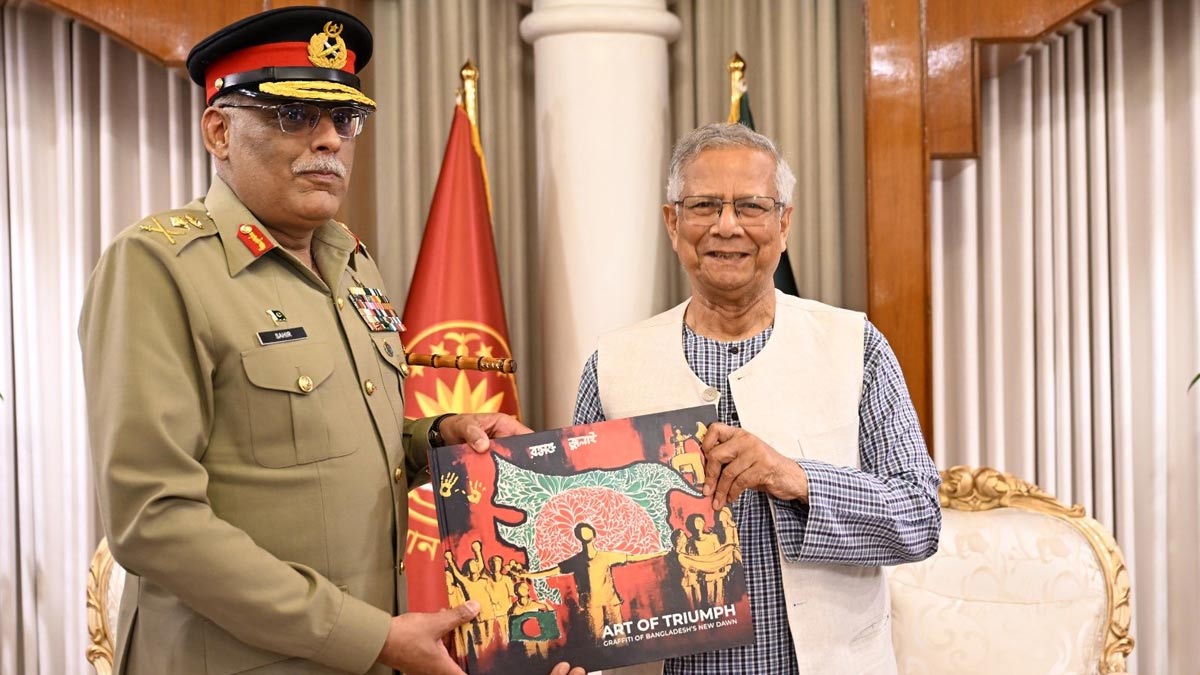
There are diplomatic gifts, and then there are diplomatic grenades wrapped in ribbon. When Muhammad Yunus, Bangladesh’s interim chief adviser, handed Pakistan’s Chairman of the Joint Chiefs of Staff a coffee-table book, it wasn’t the gesture that raised eyebrows; it was the cover.
Printed boldly across it was a stylised map that appeared to swallow chunks of India’s Northeast into a “Greater Bangladesh.” For a man who once redrew the map of microfinance, Yunus seems now to be flirting with redrawing actual borders.
The symbolism didn’t go unnoticed in New Delhi. For India, this is serious business; the Northeast isn’t a side-effect of policy, it IS policy.
A pattern, a fetish
Those who have followed the recent diplomatic flourishes of Yunus know this was not an isolated faux pas. It is the latest chapter in what can only be described as an emerging fetish, a recurring and almost performative fascination with India’s Northeast.
Earlier this year, Yunus told a Beijing audience that India’s eastern states were “land-locked” and that Bangladesh was “the only guardian of the ocean for all this region.” The implication was unmistakable: India’s access to the Bay of Bengal runs through Dhaka’s goodwill.
Not long after, one of his advisers, a retired military officer, suggested online that Bangladesh should “occupy” the seven Northeastern states in the event of a regional war. Another, speaking to a Turkish outlet, mused about military “complementarity” with China. None of these statements were officially disowned. The silence was telling.
For India, such rhetoric does not fall under the category of eccentric chatter. It is read as intent. When Dhaka tilts away, or publicly engages in cartographical freewheeling and rhetorical land-claims, India perceives more than imbalance; it reads shifting terrain. And with Yunus in the driver’s seat, New Delhi sees signals, not noise.
Why it matters to India
The Northeast is India’s most sensitive flank, tethered to the mainland by the narrow Siliguri Corridor, sharing over 1,600 kilometres of border with Bangladesh, and historically vulnerable to infiltration and insurgency. When Dhaka plays cartographic charades, Delhi doesn’t see art; it sees alignment. The memory of insurgent havens across the border and the strategic dependence on Bangladesh for connectivity make this region more nerve than geography.
Which is why the recent Rajya Sabha discussion on a Turkey-based NGO’s reported backing of the “Sultanate-e-Bangla” project, a fantasy of an expanded Bangladesh, was not treated as trivia. The ministry of external affairs confirmed that India is “closely monitoring” such developments. In other words, New Delhi’s antennae are up, and they are pointed east.
A map is much more
To the casual observer, a distorted outline on a book cover might seem like a careless graphic designer’s misstep. But in South Asia, maps have never been neutral. They are statements of power and imagination. In our neck of the woods, maps are loaded weapons, inked in ambition.
By gifting a “Greater Bangladesh” map to a Pakistani general, Yunus effectively revived one of Dhaka’s most dangerous flirtations, the fantasy of ethno-cultural expansion cloaked as historical correction. It plays well to domestic ultra-light sentiment, but it sets off klaxons across India’s Northeast, where memories of 1971, cross-border migration, and insurgent sanctuaries remain vivid. The playbook might sound eerily familiar and touch some nerves in our country as well, but that’s for another day.
For a man celebrated globally as a peace-builder, Yunus’s recent actions suggest a different ambition, to reposition Bangladesh as a regional fulcrum capable of needling India while courting Pakistan, Turkey, and, increasingly, China. It is the kind of diplomatic choreography that risks tripping over its own symbolism.
New Delhi’s vantage point
For New Delhi, this is not merely about Bangladesh’s interim government experimenting with post-Sheikh Hasina independence. It is about an emerging ecosystem of actors, NGOs, advisers, and ideologues, attempting to recast Bangladesh’s geopolitical identity through the lens of “civilizational geography.”
India has seen this playbook before. It begins with intellectual provocation, maps, comments, and think-tank papers. If left unaddressed, this evolves into policy posturing. What makes Yunus’s case worrying is that he brings global legitimacy to these ideas. A Nobel Peace Prize laureate drawing ambiguous boundaries is far more dangerous than a fringe activist shouting a slogan.
Vindication of an earlier warning
When this author wrote in The Week (“India’s Half-Front and Bangladesh: Past, Present and Future,” February 2025) that Dhaka’s trajectory had begun to blur the lines between cooperation and competition, the intention was analytical, not prophetic. Yet the unfolding events seem to confirm the argument, that India’s eastern frontier is no longer a passive boundary but an active front in the battle of narratives, influence, and strategic depth. Bangladesh is not just a neighbour; it is India’s geopolitical mirror. What reflects from Dhaka often refracts in Guwahati, Siliguri, and Aizawl.
Caution for both capitals
Nations rarely speak in blunt commands; they prefer calibrated moves and plausible deniability. Viewed through that lens, Dhaka’s cartographic provocation is less a blunder than a probe, a test of how far symbolic revisionism can stretch before it triggers consequences. Such manoeuvres often begin as theatre and end as doctrine.
For Bangladesh, the risk is overreach: every domestic applause line invites strategic caution from India, narrowing space for trust. For India, the challenge is calibration, neither to inflate the provocation nor to ignore it. India’s best response lies in quiet firmness, reinforcing deterrence through policy and partnership, not rhetoric. Both capitals would do well to recall that in South Asia, gestures are never just gestures; they are early drafts of policy.
Final musings
Maps, once drawn, have a way of redrawing minds. Yunus’s gesture was not a cartographic error but an ideological trial balloon, a hint of how Bangladesh’s interim regime imagines its regional leverage. For New Delhi, the task is to turn symbolism into strategy, tightening economic and security integration in the Northeast, while exposing the limits of Dhaka’s flirtation with revisionism. For Dhaka, the wiser course lies in stability over spectacle. In the subcontinent’s long history, ambition etched on paper has rarely survived the weight of geography.
Abhijan Das is a strategic consulting and national security expert, and a governing body member of SHARE (Society to Harmonise Aspirations for Responsible Engagement).
The opinions expressed in this article are those of the author and do not purport to reflect the opinions or views of THE WEEK.
World