Farmers demand embankment to restrict erosion of farmland
Khandapada: With recurring annual flood waters from Kusumi and Kuanria rivers swallowing vast stretches of fertile farmland and converting those into barren sandbars, distressed farmers from basin village have once again urged the Water Resources Department to take immediate and lasting action to safeguard their land and livelihoods.
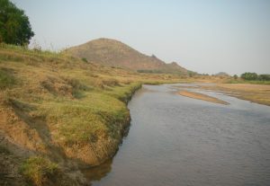
According to reports, the confluence of the Kusumi and Kuanria rivers near the villages of Kontilo, Duaragaan, and Dhanachangada has become a hotspot of agricultural destruction. Seasonal floods not only erode the riverbanks but also deposit large quantities of sand, rendering the submerged land unfit for paddy cultivation.
A stream, known as the Kamai river, formed at this junction flows through a deep gorge, nearly 150 feet deep, and eventually merges with the Mahanadi river approximately four kilometres downstream.
To protect nearby settlements and farmland, the Water Resources Department has constructed embankments on both sides of the Kamai River. A 2.5 km-long embankment runs along the southern bank, from Kamai bridge to Dhanachangada, while a 4 km stretch has been built on the left bank, from Kantilo sub-road to Dhabanighai and Bhagabat Mundia. Despite these interventions, around 1,000 acres of farmland between the Kamai river and its left embankment—including Chanapata, Patakukuta, Boluapata, Kendua, and Mareikana – continue to be submerged during floods.
Paddy farming in these areas has become nearly impossible. Instead, farmers are forced to cultivate less water-sensitive crops such as brinjal, green gram, black gram, horse gram, and groundnut, especially pulses, which yield relatively better.
However, reports said, strong flood currents continue to carry silt and sand deep into farmlands. In many cases, the riverbank is eroding significantly each year, consuming more agricultural land into the river’s bed. Frustrated by years of inaction, farmers have repeatedly appealed to the authorities for stronger protective infrastructure. Their primary demand is the construction of a 150-foot-long and 2-metre-high stone embankment (escape structure) at the confluence of the Kusumi and Kuanri rivers, downstream. They believe such a structure would trap incoming flood debris and minimise sand deposits, providing a much-needed shield for their land.
During peak flood season, the Kamai River rises dramatically, often breaching its banks and flowing at heights of 25 to 30 feet. A well-designed embankment, farmers argue, would prevent such overflows and reduce damage to cropland. However, despite repeated appeals from affected farmers over the years, the authorities have allegedly failed to implement permanent flood control measures. Though the state government spends crores annually on embankment maintenance and new constructions, allegations have surfaced that the funds are being misused or misdirected without addressing urgent needs.
Meanwhile, Assistant Engineer of the Water Resources Department, Ram Mohan Behera, acknowledged the concern and said that if the embankment is deemed necessary, the suggestion will be forwarded to higher departmental authorities. “After an on-site inspection, appropriate measures would be undertaken,” he said.
News