India’s eye in the sky: NISAR mission expected to take off by end of July
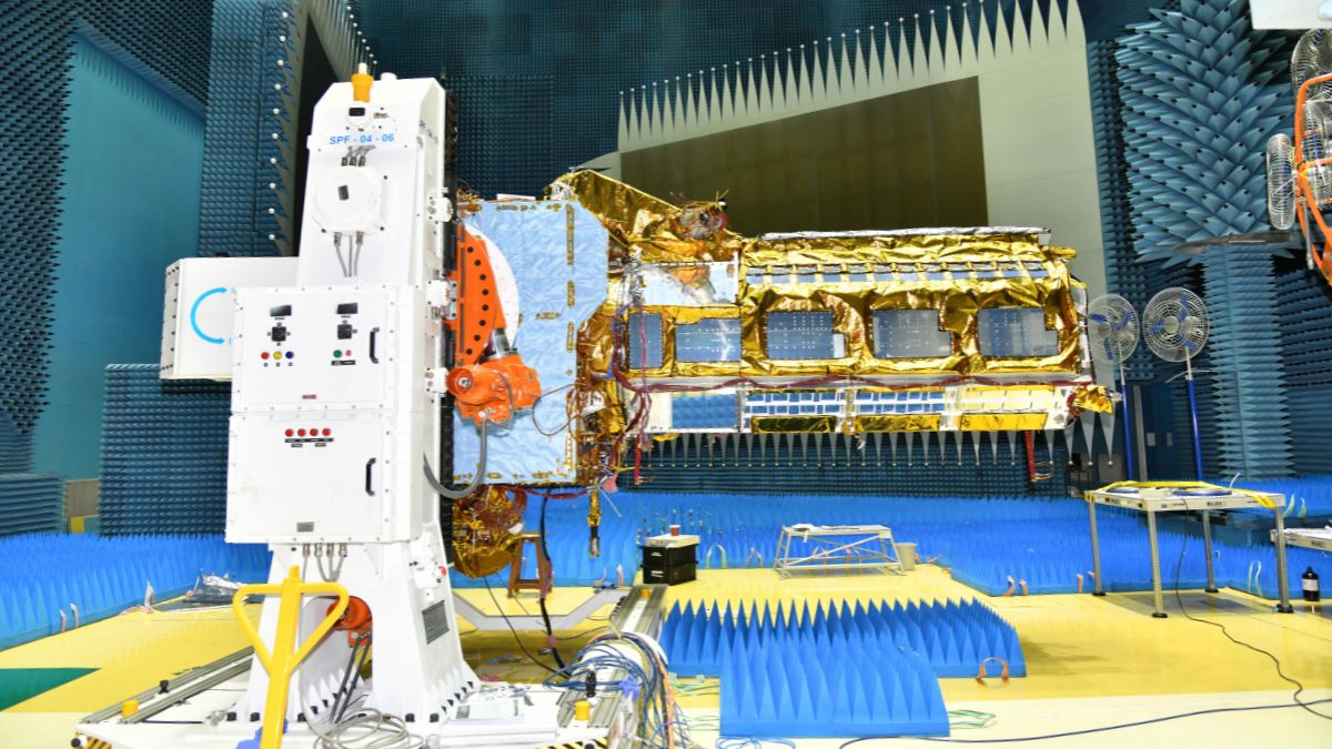 The NASA-ISRO Synthetic Aperture Radar satellite | ISRO
The world is about to witness one of the most ambitious space partnerships in history. When the NASA-ISRO Synthetic Aperture Radar satellite, fondly called NISAR, blasts off from Sriharikota sometime at the end of July, it will mark a defining moment for both Indian space technology and global Earth observation. This isn’t just another satellite launch; it’s India stepping into the big league of space science while solving some of humanity’s most pressing challenges.
NISAR represents something beautiful in today’s divided world: two nations working together for the greater good of our planet. The United States and India have combined their best technologies to create what will likely be the world’s most expensive Earth-imaging satellite at 1.5 billion dollars. NASA brings its advanced L-band radar system, while ISRO contributes its proven S-band radar technology and, crucially, the launch vehicle. This isn’t just about sharing costs; it’s about sharing dreams and expertise.
What makes this partnership even more remarkable is how it showcases India’s growing space capabilities. ISRO isn’t just providing the rocket; they have built the entire satellite body, integrated all systems at their Bengaluru facility, and will manage the mission from Indian soil. The fact that NASA trusts ISRO with such a critical mission speaks volumes about how far Indian space technology has come since the days when foreign experts questioned our ability to reach Mars.
“NISAR’s real superpower lies in its unique dual-frequency radar system. While other satellites use single-frequency radars, NISAR combines L-band and S-band radars working together like a pair of super-powered eyes. The L-band can penetrate thick forests and see through dense vegetation, while the S-band provides crystal-clear surface details. Together, they create a vision system that can see what no other satellite has seen before,” explained space expert Girish Linganna.
These capabilities will revolutionise how we understand our changing planet. NISAR will map the entire Earth every 12 days with a resolution so fine it can detect ground movements of just a few millimetres. Imagine being able to watch glaciers retreat in real-time, track earthquake damage as it happens, or monitor crop health from space with unprecedented accuracy.
The most exciting aspect is that NISAR reflects India’s practical approach to space technology. While other countries might focus on flashy deep-space missions, India consistently chooses projects that directly benefit people on Earth. NISAR will provide farmers with precise soil moisture data to optimise irrigation, help disaster response teams assess damage within hours of earthquakes or floods, and give city planners tools to monitor urban growth and infrastructure health.
“The satellite will be particularly valuable for a country like India, which faces regular challenges from monsoons, earthquakes, and rapid urbanisation. NISAR’s ability to see through clouds and work day or night means it can monitor the monsoon’s impact on agriculture in real-time, track landslides in the Himalayas, and assess flood damage even when the skies are overcast. This isn’t just a scientific advancement, it’s potentially life-saving technology,” added Linganna.
NISAR launches at a time when Earth observation is becoming increasingly competitive. Europe’s Sentinel-1C satellite, launched in December last year, provides excellent radar imagery but uses only single-frequency radar. China has its own carbon-monitoring satellites, and private companies are launching constellation after constellation. In this crowded field, NISAR’s dual-frequency capability and free data policy will make it a game-changer.
The decision to make all NISAR data freely available within days of capture deserves special praise. In an era when data is often treated as a commodity, NASA and ISRO are choosing to share this wealth of information with researchers, students, and governments worldwide. This open approach means a farmer in Maharashtra can access the same high-quality data as a climate researcher at Harvard or a disaster management official in Bangladesh.
Experts point out that NISAR will ride to space on ISRO’s GSLV Mark II, a choice that initially raised eyebrows given the rocket’s checkered early history. But this decision perfectly illustrates ISRO’s confidence in its evolved capabilities. The GSLV Mk II has proven itself in recent years, and launching a 2.8-tonne satellite to a precise 747-kilometre orbit will demonstrate its readiness for high-stakes missions.
More importantly, this launch represents ISRO’s strategic vision. While the organisation could have played it safe with the reliable PSLV for smaller payloads, choosing GSLV for NISAR shows their commitment to pushing boundaries and preparing for even more ambitious future missions.
“When NISAR begins its three-year mission, it will join an elite club of satellites that have fundamentally changed how we see our planet. Like the weather satellites that now make accurate forecasting possible, or the GPS constellation that revolutionised navigation, NISAR has the potential to become an indispensable tool for understanding Earth’s complex systems,” remarked Linganna.
The timing couldn’t be better. As climate change accelerates and extreme weather events become more frequent, we desperately need better tools to monitor and respond to environmental changes. NISAR will provide that capability, offering a continuous, high-resolution view of our planet’s vital signs.
Sci/Tech